Workweek to start with a warm storm and end with a cold storm
Sunday, January 4, 2026
A cloudy morning in Steamboat Springs this Sunday has given way to some noontime sun, with thirty-eight-degree temperatures in town and twenty-seven-degree temperatures at the top of the Steamboat Ski Resort. Similar to the warm storm that ended last Friday, which left seven-and-a-half inches of snowfall at mid-mountain, another warm storm is forecast to begin snowfall on Monday and last into Tuesday. After a short break, a colder storm is expected to start later Wednesday and linger into Friday.
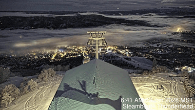 A blanket of fog covered the Yampa Valley Saturday morning after about six-tenths of an inch of liquid fell during the day Thursday and Thursday night. Even though dry air overspread the valley by Saturday morning, fog formed and persisted early in the day, as shown by the time-lapse from the Steamboat Thunderhead cam between 6:40 am and 10:40 am.
A trough of low pressure off the West Coast is now directing moisture over a ridge of high pressure over the Rockies, leading to our mix of sun and clouds. A wave of energy rounding the base of the trough will move overhead on Monday, starting precipitation as early as Monday morning. The storm will be warm, a few degrees cooler than the last storm, but that may be enough to limit the raindrops in town to perhaps a few hours around noon.
Gusty westerly winds reaching as high as 50 mph on Monday afternoon will accompany the snowfall, with snowfall briefly picking up around sunset as a cool front associated with the wave moves through. Mountain-top temperatures will slowly fall into the teens by Tuesday morning, though the best moisture may be past when the coldest temperatures arrive. We could see 3-6” at mid-mountain by the Tuesday morning report, with weather forecast models disagreeing on the amount of moisture behind the cool front and whether snow showers continue into Tuesday morning, with another inch or two of fluffier snowfall possible.
Meanwhile, incoming northern Pacific energy will force the West Coast trough to shear, with the southern end forming an eddy and perhaps affecting our next storm, and the northern end moving across the northern Rockies. The northern wave may drag another weak but dry cool front through our area on Tuesday afternoon, for another afternoon of gusty winds.
More incoming Pacific energy will carry a wave of energy and moisture, now over northern Japan, across the Aleutian Islands on Monday and the Gulf of Alaska on Tuesday. Cold arctic air from the north will be ingested into and strengthen the wave, bringing a storm across the Pacific Northwest on Wednesday.
Weather forecast models have struggled with the speed and strength of this wave and its eventual interaction with the remnants of the West Coast eddy. Right now, flurries could start Wednesday afternoon or evening, with stronger showers following when a leading cool front grazes our area on Thursday morning, and again when the much stronger arctic front follows on Thursday night.
While colder air by Friday morning is the more certain outcome, moisture availability is uncertain as it will depend upon the interaction between the cold storm from the northwest and the moist eddy to the south. It is also unclear whether the storm slows or even stalls, perhaps prolonging snowfall into Friday morning. We could see as much as 6-12”, or less than half that, depending upon the storm’s evolution.
Let’s hope these two storms can produce since warm and dry weather is forecast for the weekend, lasting into and perhaps through the following workweek. I’ll have more details on the colder storm to end this workweek in my next regularly scheduled weather narrative on Thursday afternoon.


