Arctic front to bring cold and snowy weekend
Thursday, January 22, 2026
Temperatures in Steamboat Springs at noon on this Thursday are near thirty degrees in town and twenty degrees at the top of the Steamboat Ski Resort under mostly sunny skies. An arctic system and a subtropical system will soon interact, bringing snowfall starting later on Friday and cold temperatures for the weekend.
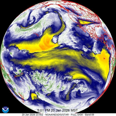 An eddy of low pressure has formed off the coast of southern California underneath a ridge of high pressure extending southward from Alaska. The formation of the eddy and its ingestion of tropical and subtropical moisture, representative of an atmospheric river, is clear in the accompanying thirty-two-hour time-lapse of water vapor satellite images between Tuesday and Thursday afternoons. Additionally, waves of energy moving over the ridge of high pressure and down its eastern side have mixed with arctic air from a persistent and deep vortex of cold air centered near Hudson Bay.
After a pleasant day today with some high clouds from the west and northwest and high temperatures in the mid-thirties, above our average of thirty degrees, the weather changes later on Friday.
Some energy moving down the ridge will force the eddy eastward, while some mixes with frigid air from central and northern Canada. This arctic air moving southward across the Northern Rockies on Friday will encounter the much warmer and wetter air moving northward around the eddy, creating a slow-moving frontal system that promises some snowfall and frigid air for all of Colorado this weekend.
Colorado will not be the only state affected, as the path of the one-time eddy will create a large band of winter weather lasting through the weekend, including likely devastating amounts of freezing rain from Texas to the Central Atlantic coast and heavy snow to the north.
Snowfall forecasts for our area are still changing, as the cold air trends further westward, with snowfall expected to start late in the day on Friday and continue into Saturday morning. We could see 3-6” of snow at mid-mountain by the Saturday morning ski report and up to a couple of inches in town, with some minor accumulations through noon before some drier air briefly passes over in the afternoon.
High temperatures will be quite cold, only reaching the low twenties in town and mid-single digits near the top of the Steamboat Ski Resort. A reinforcing wave of cold air and some moisture is now forecast to follow for the second half of the weekend, bringing some snowfall and even colder temperatures, with highs mired in the teens on Sunday in town and likely subzero up top.
Keep an eye on the Steamboat Powdercam and Mid-mountain Powdercam during the second half of the storm, as Steamboat can often do well in the cold back-end of a storm. While moisture will be limited in the very cold air, snow ratios can be absurdly high, though my feeling today is it will be too cold for anything but light snow.
The storm will be past on Monday, but temperatures will be slow to recover, especially if skies clear and Monday morning sees the predicted subzero temperatures, below our average of five degrees. Quiet weather follows for most of the workweek as a ridge of high pressure moves overhead, with unsettled weather possible around next Friday. Enjoy the wintry weekend, and check back for my next regularly scheduled weather narrative on Sunday afternoon.


