Quintessential Colorado summer days ahead
Thursday, June 8, 2017
Plenty of sunshine will be on tap for the next week as the current summer-like weather continues through the weekend. Currently, a ridge of high pressure over the Rocky Mountains has brought above normal temperatures and dry air to the Steamboat Springs area, eliminating the chances for our typical afternoon thunderstorms.
A strong and cold storm is bringing precipitation to the Pacific Northwest coast, and some energy will eject from this storm and travel well to our north over the weekend. However, the Rocky Mountain ridge will be flattened and moved eastward by the strengthening southwest flow around the storm, bringing breezy southwest winds and more dry air from the desert southwest over our region.
The Rocky Mountain ridge rebuilds for a short time around Sunday ahead of the slowly moving Pacific storm moving eastward across the Great Basin. Even though the ridge will serve to deflect the parent storm north of us towards Montana, keeping precipitation to our north, the storm is potent enough to bring an unseasonably strong cold front through the area around Monday. If the southern end of the storm had any appreciable moisture, we would see snow below 8000′ by Tuesday morning! But just much cooler temperatures will be noted for the beginning of the work week under continued breezy conditions as the front barrels through the region and backs the winds from the southwest to the west.
Winds will slacken and temperatures will warm back to normal on Wednesday, and stay that way for the rest of the work week, with any chances of precipitation confined to the end of this forecast period.
NEW - Receive my forecasts by email!
Tuesday, July 5, 2016
Exciting news for those hanging on my every word! Registered users can now have the twice-weekly forecast discussion blog emailed directly to their inbox. Simply sign in to your account and click the Settings link. You will see a new checkbox labeled SnowAlarm Forecast Blog under the Newsletter Subscriptions that allows you to receive the SnowAlarm forecast discussion blog directly to your inbox.
Not registered? No problem - simply create a free account and you will be automatically signed up!
There is no obligation to continue receiving the forecast discussion blog after you sign up - simply go to your Settings and uncheck the box labeled SnowAlarm Forecast Blog under the Newsletter Subscriptions and you will be immediately unsubscribed.
SnowAlarm registration and login back for the 2013-2014 ski season
Saturday, December 7, 2013
The SnowAlarm login and registration system is now back for this winter season. In addition to changes you’ve seen on the site including the new layout and mobile-friendly versions, I also have a new registration system. Longtime users of the site will not like it, but ‘ve had to implement a revenue generating model for SnowAlarm.
Unlimited SnowAlarms for one area are still free, but multiple areas require a fee as I am no longer able to personally bear the costs of running this site. Since competitors are now charging for something I have been giving away for over 13 years, I have finally decided to consider a similar approach.
For my loyal SnowAlarm users over the years, I am offering the first payment for any product you choose at half price if you choose the same username from years past when you sign up. If you don’t see the discount on your invoice after signing up, then your username is wrong and you will have to go through the signup process again.
Additionally, your old SnowAlarm profile will be automatically resored! This is only for the first charge, and recurring products will be billed at the normal rate. Again, the half price discount will be applied to ONLY your first payment and ONLY once. Remember to choose the same username from years past when you sign up in order to receive this special discount! If you don’t see the discount on your invoice after signing up, then your username is wrong and you will have to go through the signup process again.
I have decided to still offer an unlimited number of SnowAlarms for one ski area for free. This is great option for the destination skier interested in only the ski area they are visiting. Otherwise, the following subscriptions are available:
- $1.99 for unlimited areas for 1 day. This is a one-time charge so you can enable your SnowAlarms for just that huge powder day predicted for tomorrow.
- $5 / week between Nov 1 and the third weekend of April. This is a recurring charge that occurs every week during the season.
- $10 / month between Nov 1 and the third weekend of April. This is a recurring charge that occurs every month during the season.
- $30 / year. This is a recurring charge that occurs every year.
Even though there will be no recurring charges, as part of your subscription I will start to send SnowAlarms when the first Colorado resorts open, usually late October and will continue to send then after the third weekend in April until all resorts are closed.
Sign up now and don’t miss another powder day!
SnowAlarm redesigned to be responsive and mobile-friendly
Sunday, August 25, 2013
Welcome to the 2013-2014 season. Loyal visitors to this site will notice a big difference in the layout as this site is now responsive, meaning that the layout will change depending upon screen size and the content is arranged in columns that will vertically stack as the screen size decreases.
Currenlty, the regisration and login process are not functional as I implement a new registration process.
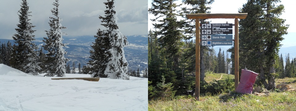
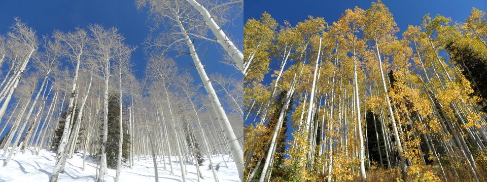
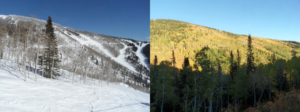
The slideshow of the homepage is very interesting as it is the the same camera perspective taken in different seasons.
 Immediately noticeable is the almost completely buried trail sign at the top of Storm Peak. The ‘winter’ shot was taken on 1 May 2011 while the summer shot was taken a few months later on 4 Septermber 2011. We received a record 489” of snow, although if the area had stayed open anoher week, we wouild have been close to 550”. Incrediably there was more snow at this time than when the season closed in mid-April.

 Note the height of the aspen trees iin the Shadows area as the winter trees have their bases covered with almost 15 feet of snow. The winter shot was takem on 23 March 2011 while the fall shot was taken almost a year earlier on 25 Sept. 2010.
Lastly, the thrid photo montage is of the Priest Creek area taken from near the Elkhead lift. As with the aspens above, the winter shot was taken on 23 March 2011 while the fall shot was taken almost a year earlier on 19 September 2010.


